
Make a donation
Chester Township topographic map
Click on the map to display elevation.
Make a donation
About this map
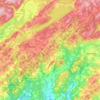
Name: Chester Township topographic map, elevation, terrain.
Location: Chester Township, Morris County, New Jersey, United States (40.71941 -74.74062 40.84112 -74.62372)
Average elevation: 207 m
Minimum elevation: 73 m
Maximum elevation: 338 m
Make a donation
Other topographic maps
Click on a map to view its topography, its elevation and its terrain.
Kenvil
United States > New Jersey > Morris County > Roxbury Township > Succasunna
Average elevation: 239 m
Washington Valley
United States > New Jersey > Morris County > Morris Township
Average elevation: 152 m
Make a donation
Powder Mill Pond Dam
United States > New Jersey > Morris County > Parsippany-Troy Hills > Tabor
Average elevation: 178 m
Make a donation
Make a donation
Mooney Mountain Park
United States > New Jersey > Morris County > Roxbury Township
Average elevation: 326 m
Make a donation
Schooleys Mountain
United States > New Jersey > Morris County > Washington Township
Average elevation: 293 m
Lake Parsippany
United States > New Jersey > Morris County > Parsippany-Troy Hills
Average elevation: 93 m
Make a donation
Pleasant Valley
United States > New Jersey > Morris County > Mendham Township
Average elevation: 156 m
Make a donation
Calais Crossroads
United States > New Jersey > Morris County > Randolph Township
Average elevation: 284 m
Washington Corner
United States > New Jersey > Morris County > Mendham Township
Average elevation: 174 m
Make a donation
Make a donation
Lake Hiawatha
United States > New Jersey > Morris County > Parsippany-Troy Hills
Average elevation: 76 m
Make a donation
Lower Montville
United States > New Jersey > Morris County > Montville Township
Average elevation: 84 m
Beach Glen
United States > New Jersey > Morris County > Rockaway Township > Beach Glen
Average elevation: 209 m
Make a donation
Floral Hill
United States > New Jersey > Morris County > Chatham Township > Floral Hill
Average elevation: 90 m
Make a donation
Rockaway Valley
United States > New Jersey > Morris County > Boonton Township
Average elevation: 181 m
Roxbury Township
United States > New Jersey > Morris County > Roxbury Township
Average elevation: 264 m
Make a donation