
Thank you for supporting this site ❤️
Make a donation
Make a donation
New Vernon topographic map
Click on the map to display elevation.
Thank you for supporting this site ❤️
Make a donation
Make a donation
About this map
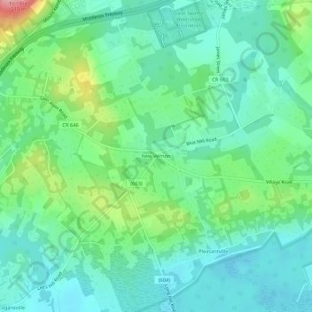
Name: New Vernon topographic map, elevation, terrain.
Average elevation: 104 m
Minimum elevation: 65 m
Maximum elevation: 213 m
Thank you for supporting this site ❤️
Make a donation
Make a donation
Other topographic maps
Click on a map to view its topography, its elevation and its terrain.
Great Swamp National Wildlife Refuge
United States > New Jersey > Morris County > Harding Township
The Great Swamp is the remnant of the bottom of the once-mighty Glacial Lake Passaic that approximately 15,000 to 11,000 years ago stretched across 30 by 10 miles (48 by 16 km) in what is presently northern New Jersey. The lake was formed by the melting waters of the retreating Wisconsin Glacier at the end of…
Average elevation: 85 m