
Robidoux topographic map
Interactive map
Click on the map to display elevation.
About this map
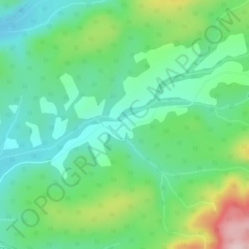
Name: Robidoux topographic map, elevation, terrain.
Average elevation: 159 m
Minimum elevation: 76 m
Maximum elevation: 354 m
Other topographic maps
Click on a map to view its topography, its elevation and its terrain.
Lac à Jim
Canada > Québec > Rivière-Bonaventure
Lac à Jim, 08675df86a5d419892aa35183d1000b4, Rivière-Bonaventure, Bonaventure, Gaspésie–Îles-de-la-Madeleine, Québec, Canada
Average elevation: 296 m
Mont Chauve
Canada > Québec > Rivière-Bonaventure
Mont Chauve, Rivière-Bonaventure, Bonaventure, Gaspésie–Îles-de-la-Madeleine, Québec, Canada
Average elevation: 145 m