
Bendeleben topographic map
Interactive map
Click on the map to display elevation.
About this map
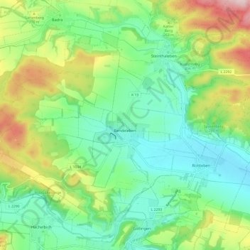
Name: Bendeleben topographic map, elevation, terrain.
Average elevation: 230 m
Minimum elevation: 135 m
Maximum elevation: 429 m
Other topographic maps
Click on a map to view its topography, its elevation and its terrain.
Arnsburg
Deutschland > Thüringen > Kyffhäuserkreis > Kyffhäuserland
Arnsburg, Papiermühle, Seega, Kyffhäuserland, Kyffhäuserkreis, Thüringen, 99707, Deutschland
Average elevation: 256 m
Numburg
Deutschland > Thüringen > Kyffhäuserkreis > Kyffhäuserland > Badra
Numburg, Badra, Kyffhäuserland, Kyffhäuserkreis, Thüringen, 99707, Deutschland
Average elevation: 197 m