
Arnsburg topographic map
Interactive map
Click on the map to display elevation.
About this map
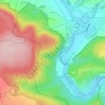
Name: Arnsburg topographic map, elevation, terrain.
Average elevation: 256 m
Minimum elevation: 155 m
Maximum elevation: 400 m
Die Arnsburg, auch Arensburg genannt, ist die Ruine einer Höhenburg auf 293 m ü. NN etwa 1,5 Kilometer südwestlich des Ortes Seega im Kyffhäuserkreis in Thüringen. Sie befindet sich auf einem Hang über dem Durchbruchstal der Wipper. Unklar ist, ob sich der Name der Burg von Adlerburg ableitet.
Other topographic maps
Click on a map to view its topography, its elevation and its terrain.
Bendeleben
Deutschland > Thüringen > Kyffhäuserkreis > Kyffhäuserland
Bendeleben, Kyffhäuserland, Kyffhäuserkreis, Thüringen, 99707, Deutschland
Average elevation: 230 m
Numburg
Deutschland > Thüringen > Kyffhäuserkreis > Kyffhäuserland > Badra
Numburg, Badra, Kyffhäuserland, Kyffhäuserkreis, Thüringen, 99707, Deutschland
Average elevation: 197 m