
Shidler topographic map
Interactive map
Click on the map to display elevation.
About this map
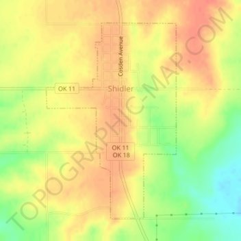
Name: Shidler topographic map, elevation, terrain.
Location: Shidler, Osage County, Oklahoma, United States (36.76738 -96.67161 36.78933 -96.65339)
Average elevation: 347 m
Minimum elevation: 315 m
Maximum elevation: 365 m
Other topographic maps
Click on a map to view its topography, its elevation and its terrain.
Keystone Lake
United States > Oklahoma > Osage County > Westport
Keystone Lake, Westport, Osage County, Oklahoma, United States
Average elevation: 241 m
Skiatook
United States > Oklahoma > Osage County
Skiatook, Osage County, Oklahoma, 74070, United States
Average elevation: 222 m
McCord
United States > Oklahoma > Osage County > McCord
McCord, Osage County, Oklahoma, United States
Average elevation: 307 m
Barnsdall
United States > Oklahoma > Osage County
Barnsdall, Osage County, Oklahoma, 74002, United States
Average elevation: 236 m
Pawhuska
United States > Oklahoma > Osage County > Pawhuska > Pawhuska
Pawhuska, Osage County, Oklahoma, 74056, United States
Average elevation: 272 m
Avant
United States > Oklahoma > Osage County > Avant
Avant, Osage County, Oklahoma, 74001, United States
Average elevation: 221 m
Salt Creek
United States > Oklahoma > Osage County > Fairfax
Salt Creek, Fairfax, Osage County, Oklahoma, 74637, United States
Average elevation: 280 m
Pawhuska
United States > Oklahoma > Osage County
Pawhuska, Osage County, Oklahoma, United States
Average elevation: 264 m