
Randen topographic map
Interactive map
Click on the map to display elevation.
About this map
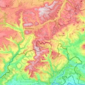
Name: Randen topographic map, elevation, terrain.
Location: Randen, Bezirk Oberklettgau, Schaffhouse, Suisse (47.69047 8.51561 47.91496 8.68967)
Average elevation: 650 m
Minimum elevation: 386 m
Maximum elevation: 934 m
Other topographic maps
Click on a map to view its topography, its elevation and its terrain.
Parc naturel régional Schaffhouse
Suisse > Schaffhouse > Bezirk Oberklettgau
Parc naturel régional Schaffhouse, Bezirk Oberklettgau, Schaffhouse, Suisse
Average elevation: 525 m