
Wels topographic map
Interactive map
Click on the map to display elevation.
About this map
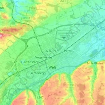
Name: Wels topographic map, elevation, terrain.
Location: Wels, Haute-Autriche, 4600, Autriche (48.12582 13.96355 48.21131 14.09076)
Average elevation: 337 m
Minimum elevation: 298 m
Maximum elevation: 422 m
Other topographic maps
Click on a map to view its topography, its elevation and its terrain.
Inn
Autriche > Haute-Autriche > Bezirk Grieskirchen > Meggenhofen
Inn, Meggenhofen, Bezirk Grieskirchen, Haute-Autriche, 4714, Autriche
Average elevation: 419 m
Hallstättersee
Autriche > Haute-Autriche > Bad Goisern am Hallstättersee
Hallstättersee, Ostuferwanderweg, Bad Goisern am Hallstättersee, Gmunden, Haute-Autriche, 4822, Autriche
Average elevation: 912 m
Almsee
Autriche > Haute-Autriche > Grünau im Almtal
Almsee, Almsee Ostuferweg, Grünau im Almtal, Gmunden, Haute-Autriche, 4645, Autriche
Average elevation: 732 m
Hinterstoder
Autriche > Haute-Autriche > Bezirk Kirchdorf
Hinterstoder, Bezirk Kirchdorf, Haute-Autriche, 4573, Autriche
Average elevation: 1,283 m
Kirchberg-Thening
Autriche > Haute-Autriche > Kirchberg-Thening
Kirchberg-Thening, Linz-Land, Haute-Autriche, 4062, Autriche
Average elevation: 316 m
Traunsee
Autriche > Haute-Autriche > Traunkirchen
Traunsee, Aueck, Traunkirchen, Gmunden, Haute-Autriche, 4801, Autriche
Average elevation: 729 m
Höllerersee
Autriche > Haute-Autriche > Sankt Pantaleon
Höllerersee, Seeleitenstraße, Sankt Pantaleon, Braunau am Inn, Haute-Autriche, 5120, Autriche
Average elevation: 455 m
Schlatt
Autriche > Haute-Autriche > Schlatt > Schlatt
Schlatt, Bezirk Vöcklabruck, Haute-Autriche, 4690, Autriche
Average elevation: 409 m