Geolocate

Tisza topographic map

Click on the map to display elevation.

Tisza

The 1800–2500 m high ridge of the Carpathian Mountains create in a semi circle the northern, eastern and southeastern boundary of the Tisza catchment. The western - southwestern reach of the watershed is comparatively low in some places – on its Hungarian and Serbian parts it is almost flat. The area is divided roughly along the centreline by the Carpathians Mountains, east of which lies the 400–600 m high plateau of the Transylvanian Basin, and the plains to the west. The highest summits of the river basin reach 1948 m in the Low Tatras (Kráľova hoľa), 2061 m in the Chornogora Mountains (Hoverla), 2303 m in the Rodna Mountains (Pietrosul Rodnei) and even higher in the Retezat Mountains of the Southern Carpathians (Peleaga, 2509 m). Areas above elevations higher than 1600 m occupy only 1% of the total; 46% of the territory lies below 200 m. The Tisza River Basin in the Slovak Republic is predominantly hilly area and the highest mountain peak in Kráľova hoľa - in the Low Tatras Mountain Range at 1948 m. The lowland area lies in the south, forming the northern edge of the Hungarian Lowland. The lowest point in the Slovak Republic is the village of Streda nad Bodrogom in the eastern Slovak lowland (96 m) in the Bodrog River Basin. The Hungarian and Vojvodina (Serbia) part of the Tisza River Basin is a flat area bordered by small ranges of hills and mountains from the north and dominated by the Hungarian lowland.

Wikipedia (CC-BY-SA 3.0)

About this map

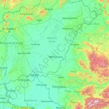
Name: Tisza topographic map, elevation, terrain.

Location: Tisza, Hungary (45.13314 20.03220 48.42575 24.24445)

Average elevation: 232 m

Minimum elevation: 68 m

Maximum elevation: 2,368 m

Other topographic maps

Click on a map to view its topography, its elevation and its terrain.

Danube

Hungary > Budapest

Average elevation: 114 m

Kakuk hegy

Hungary > Borsod-Abaúj-Zemplén > Gönc

Average elevation: 348 m

Börzsöny

Hungary > Pest

Average elevation: 249 m

Bakony

Hungary

Average elevation: 218 m

Gellért Hill

Hungary > Budapest

Average elevation: 126 m

horpa

Hungary > Borsod-Abaúj-Zemplén > Telkibánya

Average elevation: 353 m

Alsósegesd

Hungary > Somogy > Segesd

Average elevation: 161 m

Ómassa

Hungary > Borsod-Abaúj-Zemplén > Miskolc

Average elevation: 668 m

Vértes

Hungary > Komárom-Esztergom

The area of the Vértes occupies 314 km2 (121 sq mi). It is about 30 km long and 10–15 km wide. The average altitude is above sea level is 350 meters; its highest points are 487 m (Nagy-Csákány), 480 m (Körtvélyes) and 479 m (Csóka-hegy). Geologically the Vértes constitute a fairly uniform structure.…

Average elevation: 245 m

Zengő

Hungary > Baranya > Hosszúhetény

Average elevation: 454 m

Maros

Hungary > Csongrád-Csanád > Apátfalva

Average elevation: 86 m

Benta

Hungary > Pest > Érd

Average elevation: 132 m

Zemplén Mountains

Hungary

Zemplén Mountains (Hungarian: [ˈzɛmpleːn]) or Tokaj Mountains (Hungarian: [ˈtokɒj]; Hungarian: Zempléni-hegység or Tokaji-hegység) is a mountain range in Hungary. The Zemplén Mountains form part of the Tokaj-Eperjes mountain chain in Hungary, known for their ecological richness and historical…

Average elevation: 206 m

Péterhegy

Hungary > Veszprém > Csopak

Average elevation: 169 m

Kiscsákó

Hungary > Békés > Orosháza

Average elevation: 87 m

Bükk-fennsík

Hungary > Borsod-Abaúj-Zemplén

Average elevation: 500 m

Gyermekváros

Hungary > Veszprém > Zánka

Average elevation: 133 m

Horvátkimle

Hungary > Győr-Moson-Sopron > Kimle

Average elevation: 116 m

Székhegy

Hungary > Pest > Vác

Average elevation: 145 m

Ziggurat

Hungary > Budapest

Average elevation: 108 m

Malomi-dűlő

Hungary > Pest > Páty

Average elevation: 181 m

Újfalu

Hungary > Baranya > Kozármisleny

Average elevation: 174 m

Magyar

Hungary > Veszprém > Balatonhenye

Average elevation: 315 m

Somogy vármegye

Hungary

Average elevation: 163 m

Zab-szék

Hungary > Bács-Kiskun > Szabadszállás

Average elevation: 93 m

Tiszavalki-medence

Hungary > Heves > Poroszló

Average elevation: 87 m

Dombay-tó

Hungary > Baranya > Pécsvárad

Average elevation: 239 m

Danube

Hungary > Győr-Moson-Sopron

Average elevation: 119 m

Csúcs-hegy

Hungary > Budapest

Average elevation: 261 m

Liszkó gyártelep

Hungary > Heves > Sirok

Average elevation: 197 m

Bucka

Hungary > Fejér > Csákberény

Average elevation: 222 m

Homokpusztai gyep TVT

Hungary > Pest > Pusztavacs

Average elevation: 132 m

Pannonian Basin

Hungary > Pest > Cegléd

Pannonian basin vs Carpathian basin: On the territory of present-day Hungary the ancient Roman Pannonia province was located only on Transdanubian territories, however the Great Hungarian Plain was not part of Pannonia province. This comprises less than 29% of modern Hungary, therefore Hungarian geographers…

Average elevation: 99 m

Tahi

Hungary > Pest

Average elevation: 161 m

Mátra

Hungary > Heves

Average elevation: 285 m

Zichy-kastély

Hungary > Veszprém > Várpalota

Average elevation: 166 m

Bakony

Hungary

Average elevation: 218 m

Szentléránt

Hungary > Vas > Sorkifalud

Average elevation: 186 m

Avas

Hungary > Borsod-Abaúj-Zemplén > Miskolc

Average elevation: 159 m

Golgota

Hungary > Bács-Kiskun > Lajosmizse

Average elevation: 136 m

Pécs

Hungary > Baranya > Pécs

Pécs is bordered by plains to the south (elevation 120–130 m), while the Mecsek mountains rise up to elevations of 400–600 meters behind the city. Jakab-hill, located in the western Mecsek, is 592 m (1942 ft) tall, Tubes, straight above Pécs, is 612 m (2008 ft) tall, and Misina is 535 m (1755 ft) tall.…

Average elevation: 210 m

Gellért Hill

Hungary > Budapest

Average elevation: 126 m

Körtvélyes

Hungary > Veszprém > Tés

Average elevation: 460 m

Székesfehérvár

Hungary > Fejér > Székesfehérvár

Average elevation: 150 m

Miskolc

Hungary > Borsod-Abaúj-Zemplén > Miskolc

Average elevation: 206 m

Debrecen

Hungary > Hajdú-Bihar > Debrecen

Average elevation: 119 m

Veszprém

Hungary > Veszprém > Veszprém

Average elevation: 275 m

Gellért

Hungary > Borsod-Abaúj-Zemplén > Olaszliszka

Average elevation: 153 m

Érd

Hungary > Pest > Érd > Érd

Average elevation: 133 m

Ábrahám

Hungary > Domaszék

Average elevation: 88 m

Eger

Hungary > Heves > Eger

Average elevation: 244 m

Szeged

Hungary > Csongrád-Csanád County > Szeged

Average elevation: 82 m

Ágfalva

Hungary > Győr-Moson-Sopron > Ágfalva > Ágfalva

Average elevation: 285 m

Maros

Hungary > Csongrád-Csanád County > Apátfalva

Average elevation: 86 m

Tatabánya

Hungary > Komárom-Esztergom > Tatabánya

Average elevation: 218 m

Várpalota

Hungary > Veszprém > Várpalota > Várpalota

Average elevation: 189 m

Nyáras-sziget

Hungary > Győr-Moson-Sopron > Dunasziget

Average elevation: 126 m

Barcs

Hungary > Somogy > Barcs > Barcs

Average elevation: 111 m

Salgótarján

Hungary > Nógrád > Salgótarján

Average elevation: 288 m

Bükk

Hungary > Heves

Average elevation: 388 m

Göd

Hungary > Pest > Göd > Göd

Average elevation: 124 m

Kaposvár

Hungary > Somogy > Kaposvár

Average elevation: 173 m

Szolnok

Hungary > Jász-Nagykun-Szolnok > Szolnok

Average elevation: 87 m

Makó

Hungary > Csongrád-Csanád County > Makó > Makó

Average elevation: 83 m

Szentendre

Hungary > Pest > Szentendre > Szentendre

Average elevation: 137 m

Alibánfa

Hungary > Zala > Alibánfa > Alibánfa

Average elevation: 155 m

Nagysáp

Hungary > Komárom-Esztergom > Nagysáp > Nagysáp

Average elevation: 197 m

Gyula

Hungary > Békés > Gyula > Gyula

Average elevation: 88 m

Mátraalmás

Hungary > Nógrád > Szuha > Mátraalmás

Average elevation: 624 m

Zalaegerszeg

Hungary > Zala > Zalaegerszeg

Average elevation: 199 m

Gyöngyös

Hungary > Heves > Gyöngyös > Gyöngyös

Average elevation: 197 m

Komló

Hungary > Baranya > Komló > Komló

Average elevation: 273 m

Dunafalva

Hungary > Bács-Kiskun > Dunafalva > Dunafalva

Average elevation: 97 m

Fót

Hungary > Pest > Fót > Fót

Average elevation: 174 m

Nagyegyháza

Hungary > Fejér > Óbarok > Nagyegyháza

Average elevation: 231 m

Tigers

Hungary > Budapest

Average elevation: 111 m

Maros

Hungary > Csongrád-Csanád County > Apátfalva

Average elevation: 86 m

Danube

Hungary > Budapest

Average elevation: 125 m