
Thank you for supporting this site ❤️
Make a donation
Make a donation
Bükk topographic map
Click on the map to display elevation.
Thank you for supporting this site ❤️
Make a donation
Make a donation
About this map
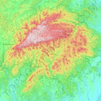
Name: Bükk topographic map, elevation, terrain.
Location: Bükk, Heves, Northern Hungary, Great Plain and North, Hungary (47.91364 20.32057 48.15773 20.72735)
Average elevation: 388 m
Minimum elevation: 122 m
Maximum elevation: 951 m
Thank you for supporting this site ❤️
Make a donation
Make a donation
Other topographic maps
Click on a map to view its topography, its elevation and its terrain.
Thank you for supporting this site ❤️
Make a donation
Make a donation
Bélapátfalva
Bélapátfalva is a town in Heves County, in Hungary, located north of the city of Eger. The town is located inside the Eger river valley at an altitude of 311 meters above sea level. Facing the town is the Bél-kő mountain which rises 811 meters and is one of the highest peaks of the Bükk mountains. Because…
Average elevation: 413 m
Thank you for supporting this site ❤️
Make a donation
Make a donation
Thank you for supporting this site ❤️
Make a donation
Make a donation
Thank you for supporting this site ❤️
Make a donation
Make a donation
Thank you for supporting this site ❤️
Make a donation
Make a donation
Thank you for supporting this site ❤️
Make a donation
Make a donation