
Mechelen topographic map
Interactive map
Click on the map to display elevation.
About this map
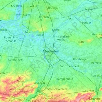
Name: Mechelen topographic map, elevation, terrain.
Location: Mechelen, Antwerpen, Vlaanderen, UNSET, België (50.86814 4.32035 51.18814 4.64035)
Average elevation: 17 m
Minimum elevation: -3 m
Maximum elevation: 97 m
Other topographic maps
Click on a map to view its topography, its elevation and its terrain.
Tivolipark
België > Antwerpen > Mechelen > Mechelen
Tivolipark, Mechelen, Antwerpen, Vlaanderen, 2800, België
Average elevation: 5 m