
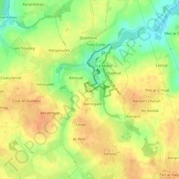
Le Niagara topographic map
Interactive map
Click on the map to display elevation.
About this map
Name: Le Niagara topographic map, elevation, terrain.
Average elevation: 85 m
Minimum elevation: 61 m
Maximum elevation: 99 m
Other topographic maps
Click on a map to view its topography, its elevation and its terrain.
Carhaix-Plouguer
Carhaix-Plouguer, Châteaulin, Finistère, Bretanha, França metropolitana, 29270, França
Average elevation: 120 m
Camlez
França > Bretanha > Côtes-d'Armor
Camlez, Lannion, Côtes-d'Armor, Bretanha, França metropolitana, 22450, França
Average elevation: 66 m
Port-Louis
Port-Louis, Lorient, Morbihan, Bretanha, França metropolitana, 56290, França
Average elevation: 3 m
Saint-Aubin-du-Cormier
França > Bretanha > Ille-et-Vilaine
Saint-Aubin-du-Cormier, Rennes, Ille-et-Vilaine, Bretanha, França metropolitana, 35140, França
Average elevation: 86 m
Roudouallec
França > Bretanha > Morbihan > Roudouallec
Roudouallec, Pontivy, Morbihan, Bretanha, França metropolitana, 56110, França
Average elevation: 182 m
Rennes
França > Bretanha > Ille-et-Vilaine > Rennes
Rennes, Ille-et-Vilaine, Bretanha, França metropolitana, 35000, França
Average elevation: 63 m
Kerambellec
França > Bretanha > Finistère > Lanildut > Kerambellec
Kerambellec, Lanildut, Brest, Finistère, Bretanha, França metropolitana, 29840, França
Average elevation: 30 m
Cavan
França > Bretanha > Côtes-d'Armor
Cavan, Lannion, Côtes-d'Armor, Bretanha, França metropolitana, 22140, França
Average elevation: 88 m
Redon
França > Bretanha > Ille-et-Vilaine > Redon
Redon, Ille-et-Vilaine, Bretanha, França metropolitana, 35600, França
Average elevation: 17 m
Châteauneuf-du-Faou
França > Bretanha > Châteauneuf-du-Faou
Châteauneuf-du-Faou, Châteaulin, Finistère, Bretanha, França metropolitana, 29520, França
Average elevation: 115 m
Château de Lysandré
França > Bretanha > Côtes-d'Armor > Plouha > Kergroas
Château de Lysandré, D 84, Kergroas, Plouha, Guingamp, Côtes-d'Armor, Bretanha, França metropolitana, 22580, França
Average elevation: 80 m
Moëlan-sur-Mer
França > Bretanha > Moëlan-sur-Mer
Moëlan-sur-Mer, Quimper, Finistère, Bretanha, França metropolitana, 29350, França
Average elevation: 37 m
Le Champs du Bois
França > Bretanha > Vern-sur-Seiche > Le Champs du Bois
Le Champs du Bois, Vern-sur-Seiche, Rennes, Ille-et-Vilaine, Bretanha, França metropolitana, 35770, França
Average elevation: 52 m
Bretagne
França > Bretanha > Landerneau > Saint-Caradec
Bretagne, França metropolitana, França
Average elevation: 50 m
Camaret-sur-Mer
França > Bretanha > Camaret-sur-Mer
Camaret-sur-Mer, Châteaulin, Finistère, Bretanha, França metropolitana, 29570, França
Average elevation: 11 m
Atalante Champeaux
Atalante Champeaux, Bourg l'Évesque - La Touche - Moulin du Comte, Quartiers Ouest, Rennes, Ille-et-Vilaine, Bretanha, França metropolitana, 35011, França
Average elevation: 37 m
Plorec-sur-Arguenon
França > Bretanha > Plorec-sur-Arguenon
Plorec-sur-Arguenon, Dinan, Côtes-d'Armor, Bretanha, França metropolitana, 22130, França
Average elevation: 68 m
Saint-Martin-des-Champs
França > Bretanha > Saint-Martin-des-Champs
Saint-Martin-des-Champs, Morlaix, Finistère, Bretanha, França metropolitana, 29600, França
Average elevation: 73 m
Saint-Jean-Brévelay
França > Bretanha > Saint-Jean-Brévelay
Saint-Jean-Brévelay, Pontivy, Morbihan, Bretanha, França metropolitana, 56660, França
Average elevation: 101 m
Larmor-Plage
França > Bretanha > Larmor-Plage
Larmor-Plage, Lorient, Morbihan, Bretanha, França metropolitana, 56260, França
Average elevation: 6 m
Saint-Michel-en-Grève
França > Bretanha > Saint-Michel-en-Grève
Saint-Michel-en-Grève, Lannion, Côtes-d'Armor, Bretanha, França metropolitana, 22300, França
Average elevation: 55 m
Pont-Croix
França > Bretanha > Pont-Croix
Pont-Croix, Quimper, Finistère, Bretanha, França metropolitana, 29790, França
Average elevation: 51 m
Sainte-Hélène
França > Bretanha > Sainte-Hélène
Sainte-Hélène, Lorient, Morbihan, Bretanha, França metropolitana, 56700, França
Average elevation: 7 m
Le Kerjean
Le Kerjean, Guingamp, Côtes-d'Armor, Bretanha, França metropolitana, 22110+, França
Average elevation: 217 m
Poul an Ranet
França > Bretanha > Saint-Gilles-les-Bois
Poul an Ranet, Saint-Gilles-les-Bois, Guingamp, Côtes-d'Armor, Bretanha, França metropolitana, 22290, França
Average elevation: 92 m
La Chapelle-Bouëxic
França > Bretanha > La Chapelle-Bouëxic
La Chapelle-Bouëxic, Redon, Ille-et-Vilaine, Bretanha, França metropolitana, 35330, França
Average elevation: 76 m