
Carhaix-Plouguer topographic map
Interactive map
Click on the map to display elevation.
Carhaix-Plouguer
Carhaix is located in the Poher, an important territory of Brittany, sandwiched between the Arrée Mountains to the north and the Black Mountains to the south. The agglomeration developed mainly on a plateau located at 140 meters above sea level, gently sloping towards the west, the highest elevations being eastwards beyond the agglomeration towards 155–169 meters above sea level. This plateau is limited to the north by the valley of the Hyères (60 meters elevation that imposed the construction of an aqueduct in Roman times to cross it), which flows to 80 meters above sea level, and south by the stream of the Madeleine whose route was taken again by the channel of Nantes in Brest. The Hyères sometimes causes serious floods: in March 1903, the Sainte-Catherine chapel located in Plounevézel but at the limit of Carhaix, had water up to the roof and in 1910 to the stained glass windows.
About this map
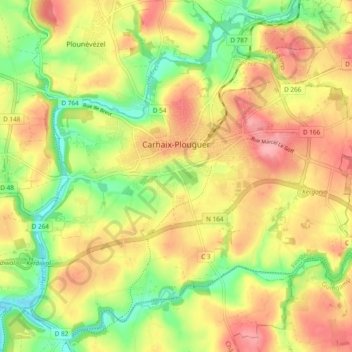
Name: Carhaix-Plouguer topographic map, elevation, terrain.
Average elevation: 120 m
Minimum elevation: 66 m
Maximum elevation: 169 m
Other topographic maps
Click on a map to view its topography, its elevation and its terrain.
Moulin du Bois
France > Brittany > Finistère > Hôpital-Camfrout > L'Hôpital-Camfrout
Average elevation: 48 m
Résidence du Bois Pleuven
France > Brittany > Finistère > Résidence du Bois Pleuven
Average elevation: 97 m