
Mount Rainier National Park topographic map
Interactive map
Click on the map to display elevation.
About this map
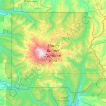
Name: Mount Rainier National Park topographic map, elevation, terrain.
Average elevation: 1,412 m
Minimum elevation: 402 m
Maximum elevation: 4,378 m
Mount Rainier National Park is an American national park located in southeast Pierce County and northeast Lewis County in Washington state. The park was established on March 2, 1899 as the fifth national park in the United States, preserving 236,381 acres (369.3 sq mi; 956.6 km2) including all of Mount Rainier, a 14,411-foot (4,392 m) stratovolcano. The mountain rises abruptly from the surrounding land with elevations in the park ranging from 1,600 feet to over 14,000 feet (490–4,300 m). The highest point in the Cascade Range, Mount Rainier is surrounded by valleys, waterfalls, subalpine meadows, and 91,000 acres (142.2 sq mi; 368.3 km2) of old-growth forest. More than 25 glaciers descend the flanks of the volcano, which is often shrouded in clouds that dump enormous amounts of rain and snow.
Other topographic maps
Click on a map to view its topography, its elevation and its terrain.
Gig Harbor
United States > Washington > Pierce County
Gig Harbor, Pierce County, Washington, 98335, United States
Average elevation: 49 m
Bonney Lake
United States > Washington > Pierce County
Bonney Lake, Pierce County, Washington, United States
Average elevation: 152 m
Tacoma
United States > Washington > Pierce County
Tacoma, Pierce County, Washington, United States
Average elevation: 67 m
Orting
United States > Washington > Pierce County
Orting, Pierce County, Washington, 98360, United States
Average elevation: 112 m
Paul Peak
United States > Washington > Pierce County
Paul Peak, Pierce County, Washington, United States
Average elevation: 1,124 m
Hope
United States > Washington > Pierce County > Fox Island
Hope, Fox Island, Pierce County, Washington, 98329, United States
Average elevation: 26 m
Anderson Island
United States > Washington > Pierce County
Anderson Island, Pierce County, Washington, 98303, United States
Average elevation: 20 m
Edgewood
United States > Washington > Pierce County
Edgewood, Pierce County, Washington, United States
Average elevation: 72 m
Yakima Peak
United States > Washington > Pierce County
Yakima Peak, Pierce County, Washington, United States
Average elevation: 1,591 m
Elk Plain
United States > Washington > Pierce County
Elk Plain, Pierce County, Washington, United States
Average elevation: 143 m
Fife
United States > Washington > Pierce County
Fife, Pierce County, Washington, 98424, United States
Average elevation: 20 m
Prairie Ridge
United States > Washington > Pierce County
Prairie Ridge, Pierce County, Washington, United States
Average elevation: 194 m
Key Peninsula
United States > Washington > Pierce County
Key Peninsula, Pierce County, Washington, United States
Average elevation: 36 m
Eatonville
United States > Washington > Pierce County
Eatonville, Pierce County, Washington, United States
Average elevation: 244 m
Lakewood
United States > Washington > Pierce County
Lakewood, Pierce County, Washington, United States
Average elevation: 81 m
Wilkeson
United States > Washington > Pierce County
Wilkeson, Pierce County, Washington, United States
Average elevation: 298 m
Mowich Lake
United States > Washington > Pierce County
Mowich Lake, Pierce County, Washington, United States
Average elevation: 1,561 m
Glencove
United States > Washington > Pierce County
Glencove, Pierce County, Washington, 98394, United States
Average elevation: 43 m
Frederickson
United States > Washington > Pierce County
Frederickson, Pierce County, Washington, 98387, United States
Average elevation: 134 m
South Hill
United States > Washington > Pierce County
South Hill, Pierce County, Washington, United States
Average elevation: 140 m
Midland
United States > Washington > Pierce County
Midland, Pierce County, Washington, United States
Average elevation: 126 m
Graham
United States > Washington > Pierce County
Graham, Pierce County, Washington, 09339, United States
Average elevation: 205 m
North Puyallup
United States > Washington > Pierce County
North Puyallup, Pierce County, Washington, 98372, United States
Average elevation: 46 m
Waller
United States > Washington > Pierce County > Tacoma
Waller, Tacoma, Pierce County, Washington, 98443, United States
Average elevation: 59 m
Sunrise
United States > Washington > Pierce County
Sunrise, Pierce County, Washington, United States
Average elevation: 1,755 m
Alderton
United States > Washington > Pierce County
Alderton, Pierce County, Washington, 98347, United States
Average elevation: 54 m
Gorden Woods
United States > Washington > Pierce County > Fort Lewis
Gorden Woods, Fort Lewis, Pierce County, Washington, 98493, United States
Average elevation: 76 m
Sumner
United States > Washington > Pierce County
Sumner, Pierce County, Washington, United States
Average elevation: 91 m
Buckley
United States > Washington > Pierce County
Buckley, Pierce County, Washington, United States
Average elevation: 222 m
Parkland
United States > Washington > Pierce County
Parkland, Pierce County, Washington, United States
Average elevation: 104 m
Kapowsin
United States > Washington > Pierce County
Kapowsin, Pierce County, Washington, 98344, United States
Average elevation: 212 m
Fox Island
United States > Washington > Pierce County
Fox Island, Pierce County, Washington, 98333, United States
Average elevation: 19 m
Ashford
United States > Washington > Pierce County
Ashford, Pierce County, Washington, 98330, United States
Average elevation: 661 m
Mount Rainier
United States > Washington > Pierce County
Mount Rainier, Pierce County, Washington, United States
Average elevation: 3,912 m
Puyallup
United States > Washington > Pierce County
Puyallup, Pierce County, Washington, United States
Average elevation: 66 m
Arletta
United States > Washington > Pierce County > Artondale
Arletta, Artondale, Pierce County, Washington, 98333, United States
Average elevation: 33 m
Greenwater
United States > Washington > Pierce County
Greenwater, Pierce County, Washington, United States
Average elevation: 655 m
Spanaway
United States > Washington > Pierce County
Spanaway, Pierce County, Washington, 98404, United States
Average elevation: 118 m
Lake Tapps
United States > Washington > Pierce County > Bonney Lake
Lake Tapps, Bonney Lake, Pierce County, Washington, United States
Average elevation: 158 m
Ohop
United States > Washington > Pierce County
Ohop, Pierce County, Washington, United States
Average elevation: 463 m
Buckley
United States > Washington > Pierce County > Buckley > Buckley
Buckley, Pierce County, Washington, United States
Average elevation: 235 m
Eagle Island Marine State Park
United States > Washington > Pierce County > Johnson Landing
Eagle Island Marine State Park, Johnson Landing, Pierce County, Washington, United States
Average elevation: 21 m
Old Baldy Mountain
United States > Washington > Pierce County
Old Baldy Mountain, Pierce County, Washington, United States
Average elevation: 1,307 m
Fox Island
United States > Washington > Pierce County > Fox Island
Fox Island, Pierce County, Washington, 98333, United States
Average elevation: 20 m
Carbonado
United States > Washington > Pierce County
Carbonado, Pierce County, Washington, 98323, United States
Average elevation: 357 m
Eatonville
United States > Washington > Pierce County > Eatonville
Eatonville, Pierce County, Washington, 98328, United States
Average elevation: 327 m
Fairfax
United States > Washington > Pierce County
Fairfax, Pierce County, Washington, United States
Average elevation: 540 m
Clarks Creek
United States > Washington > Pierce County > Puyallup
Clarks Creek, Puyallup, Pierce County, Washington, 98371, United States
Average elevation: 25 m
Lakewood
United States > Washington > Pierce County > Lakewood > Lakewood
Lakewood, Pierce County, Washington, 98499-1705, United States
Average elevation: 80 m
DuPont
United States > Washington > Pierce County > DuPont > DuPont
DuPont, Pierce County, Washington, 98327, United States
Average elevation: 72 m