
Thank you for supporting this site ❤️
Make a donation
Make a donation
Ashford topographic map
Click on the map to display elevation.
Thank you for supporting this site ❤️
Make a donation
Make a donation
About this map
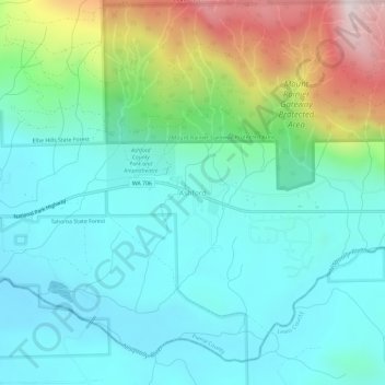
Name: Ashford topographic map, elevation, terrain.
Location: Ashford, Pierce County, Washington, 98330, United States (46.73894 -122.05162 46.77894 -122.01162)
Average elevation: 661 m
Minimum elevation: 456 m
Maximum elevation: 1,288 m
Thank you for supporting this site ❤️
Make a donation
Make a donation
Other topographic maps
Click on a map to view its topography, its elevation and its terrain.
Thank you for supporting this site ❤️
Make a donation
Make a donation
Thank you for supporting this site ❤️
Make a donation
Make a donation
Mowich Lake
United States > Washington > Pierce County
Mowich Lake is a lake located in the northwestern corner of Mount Rainier National Park in Washington state at an elevation of 4,929 feet (1,502 m). The name "Mowich" derives from the Chinook jargon word for deer.
Average elevation: 1,561 m
Thank you for supporting this site ❤️
Make a donation
Make a donation
Eagle Island Marine State Park
United States > Washington > Pierce County > Johnson Landing
Average elevation: 21 m
Thank you for supporting this site ❤️
Make a donation
Make a donation