
Make a donation
Mount Adams topographic map
Click on the map to display elevation.
Make a donation
Mount Adams
The mountain is home to diverse ecological zones, ranging from dense lower-elevation forests dominated by Douglas fir and western hemlock on its western slopes to drier ponderosa pine forests on its eastern slopes. These ecosystems support a rich array of flora and fauna, including large mammals like Roosevelt elk and black-tailed deer, as well as a variety of bird species and abundant wildflowers in the summer months.
Make a donation
About this map
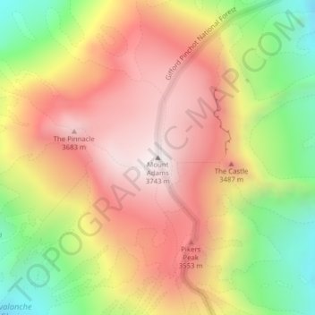
Name: Mount Adams topographic map, elevation, terrain.
Location: Mount Adams, Yakima County, Washington, United States (46.20235 -121.49101 46.20245 -121.49091)
Average elevation: 3,235 m
Minimum elevation: 2,608 m
Maximum elevation: 3,741 m
Make a donation
Other topographic maps
Click on a map to view its topography, its elevation and its terrain.
Make a donation
Make a donation
Make a donation
Make a donation
Make a donation
Make a donation
Make a donation