
Thank you for supporting this site ❤️
Make a donation
Make a donation
Safaja topographic map
Click on the map to display elevation.
Thank you for supporting this site ❤️
Make a donation
Make a donation
About this map
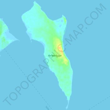
Name: Safaja topographic map, elevation, terrain.
Location: Safaja, Red Sea, Egypt, Safaga Island (26.70378 33.96008 26.77890 33.99976)
Average elevation: 1 m
Minimum elevation: -2 m
Maximum elevation: 25 m
Thank you for supporting this site ❤️
Make a donation
Make a donation
Other topographic maps
Click on a map to view its topography, its elevation and its terrain.
Thank you for supporting this site ❤️
Make a donation
Make a donation
Gabal Elba
In the higher-elevation mist zone, species of acacia, Moringa and Gabal Elba dragon tree (Dracaena ombet) form the woodland tree canopy, with ferns, mosses and succulents in the understory. The mountain intercepts moisture-bearing winds from the northeast, and the northern and northeastern slopes are more…
Average elevation: 1,004 m
Thank you for supporting this site ❤️
Make a donation
Make a donation
Thank you for supporting this site ❤️
Make a donation
Make a donation
Thank you for supporting this site ❤️
Make a donation
Make a donation
Thank you for supporting this site ❤️
Make a donation
Make a donation