
Thank you for supporting this site ❤️
Make a donation
Make a donation
Gharib Cape topographic map
Click on the map to display elevation.
Thank you for supporting this site ❤️
Make a donation
Make a donation
About this map
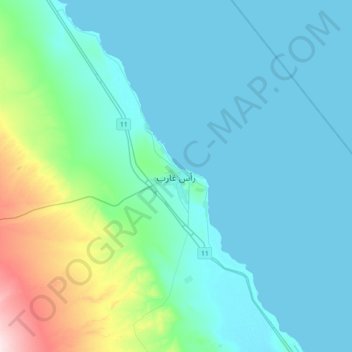
Name: Gharib Cape topographic map, elevation, terrain.
Location: Gharib Cape, Red Sea, 84715, Egypt (28.19944 32.91778 28.51944 33.23778)
Average elevation: 55 m
Minimum elevation: 0 m
Maximum elevation: 380 m
Thank you for supporting this site ❤️
Make a donation
Make a donation
Other topographic maps
Click on a map to view its topography, its elevation and its terrain.
Thank you for supporting this site ❤️
Make a donation
Make a donation
Thank you for supporting this site ❤️
Make a donation
Make a donation
Thank you for supporting this site ❤️
Make a donation
Make a donation