
Apurímac topographic map
Click on the map to display elevation.
About this map
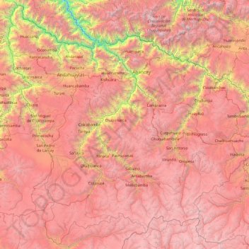
Name: Apurímac topographic map, elevation, terrain.
Location: Apurímac, Peru (-14.84273 -73.84745 -13.17071 -72.05120)
Average elevation: 3,884 m
Minimum elevation: 963 m
Maximum elevation: 6,134 m
Other topographic maps
Click on a map to view its topography, its elevation and its terrain.
Misti Volcano
According to Italian geographer Cumin 1925, there were three small man-made structures of unknown origin in the crater. He noted that they were known since 1677. Inka ceremonial platforms on the summit associated with human sacrifices were probably destroyed by human activities around 1900 AD. Professor S. I.…
Average elevation: 5,250 m