
Misti Volcano topographic map
Click on the map to display elevation.
Misti Volcano
According to Italian geographer Cumin 1925, there were three small man-made structures of unknown origin in the crater. He noted that they were known since 1677. Inka ceremonial platforms on the summit associated with human sacrifices were probably destroyed by human activities around 1900 AD. Professor S. I. Bailey from the Harvard College Observatory in 1893 installed the world's highest weather station on Misti. The station was one of several high-altitude stations built at the time, which aimed to investigate the atmosphere at such high altitudes; additionally, the Observatory performed research on the response of the human body to high altitudes and on the solar eclipse of April 16, 1893. Misti was in its time the highest permanently inhabited location on Earth. Another weather station, named "Mt. Blanc Station", was installed at the base of the volcano after 1888. Both were shut down in 1901 when the Observatory decided to only maintain a station in Arequipa; subsequently storms have erased any trace of the summit observatory. Observation of physics phenomena, such as cosmic ray measurements, were sporadically carried out on Misti during the 20th century.
About this map
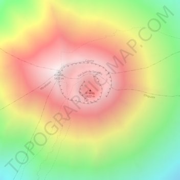
Name: Misti Volcano topographic map, elevation, terrain.
Average elevation: 5,250 m
Minimum elevation: 4,515 m
Maximum elevation: 5,821 m