
Thank you for supporting this site ❤️
Make a donation
Make a donation
Plingshult topographic map
Click on the map to display elevation.
Thank you for supporting this site ❤️
Make a donation
Make a donation
About this map
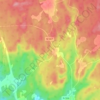
Name: Plingshult topographic map, elevation, terrain.
Location: Plingshult, Laholms kommun, Halland County, Sweden (56.62067 13.17928 56.66067 13.21928)
Average elevation: 141 m
Minimum elevation: 81 m
Maximum elevation: 180 m
Thank you for supporting this site ❤️
Make a donation
Make a donation
Other topographic maps
Click on a map to view its topography, its elevation and its terrain.
Thank you for supporting this site ❤️
Make a donation
Make a donation
Thank you for supporting this site ❤️
Make a donation
Make a donation