
West Delhi District topographic map
Interactive map
Click on the map to display elevation.
About this map
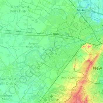
Name: West Delhi District topographic map, elevation, terrain.
Location: West Delhi District, Delhi, Inde (28.59590 76.95067 28.70079 77.19694)
Average elevation: 219 m
Minimum elevation: 204 m
Maximum elevation: 267 m
Other topographic maps
Click on a map to view its topography, its elevation and its terrain.
Saket
Inde > Delhi > Hauz Khas Tehsil
Saket, Hauz Khas Tehsil, South Delhi District, Delhi, Inde
Average elevation: 231 m
Mayur Vihar Tehsil
Mayur Vihar Tehsil, East Delhi District, Delhi, Inde
Average elevation: 204 m
Karol Bagh Tehsil
Inde > Delhi > Karol Bagh Tehsil
Karol Bagh Tehsil, Central Delhi, Delhi, Inde
Average elevation: 230 m