
New Delhi topographic map
Interactive map
Click on the map to display elevation.
About this map
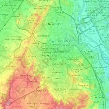
Name: New Delhi topographic map, elevation, terrain.
Location: New Delhi, Delhi, Inde (28.48122 77.05037 28.64568 77.25514)
Average elevation: 230 m
Minimum elevation: 193 m
Maximum elevation: 290 m
Située dans le Nord de l'Inde, la capitale indienne se trouve à 238 km au nord-est de Jaipur, à 691 km au sud-est d'Islamabad, à 778 km au nord-est d'Ahmedabad, à 800 km à l'ouest de Kathmandou, à 1 151 km au nord-nord-est de Bombay, à 1 303 km à l'ouest-nord-ouest de Calcutta et à 6 588 km à l'est de Paris. New Delhi constitue une municipalité à l'intérieur du territoire de Delhi. Bien qu'édifiée à proximité de la Yamuna, un affluent du Gange, la municipalité de New Delhi ne borde pas directement cette rivière. La plaine alluviale formée par la Yamuna abrite un sol fertile mais inondable. La capitale indienne se trouve à une altitude moyenne de 216 mètres.
Other topographic maps
Click on a map to view its topography, its elevation and its terrain.
Saket
Inde > Delhi > Hauz Khas Tehsil
Saket, Hauz Khas Tehsil, South Delhi District, Delhi, Inde
Average elevation: 231 m
Mayur Vihar Tehsil
Mayur Vihar Tehsil, East Delhi District, Delhi, Inde
Average elevation: 204 m
Karol Bagh Tehsil
Inde > Delhi > Karol Bagh Tehsil
Karol Bagh Tehsil, Central Delhi, Delhi, Inde
Average elevation: 230 m