
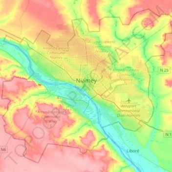
Niamey topographic map
Interactive map
Click on the map to display elevation.
About this map
Name: Niamey topographic map, elevation, terrain.
Location: Niamey, Niger (13.38296 1.96095 13.64734 2.26424)
Average elevation: 225 m
Minimum elevation: 176 m
Maximum elevation: 273 m
The Niamey region straddles between the Liptako, corresponding to the northern extremity of the East ridge of Man, and the south-western edge of the Iullemmeden basin. Covering an area of over 250 km2 (97 sq mi), the metropolitan area sits atop two plateaux reaching 218 m (715 ft) in altitude, bisected by the Niger River. At Niamey, the river, running almost straight SSE from Gao, Mali, makes a series of wide bends. The city was founded on the east ("left bank") of the river as it meanders from west to east flow to run almost directly south. A series of marshy islands begin at Niamey and extend south in the river.
Other topographic maps
Click on a map to view its topography, its elevation and its terrain.