
Saint-Médard topographic map
Interactive map
Click on the map to display elevation.
About this map
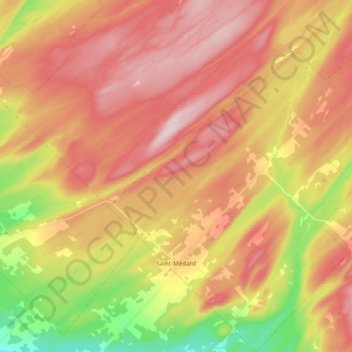
Name: Saint-Médard topographic map, elevation, terrain.
Location: Saint-Médard, Les Basques, Bas-Saint-Laurent, Québec, Canada (48.01054 -68.94178 48.13934 -68.75487)
Average elevation: 348 m
Minimum elevation: 176 m
Maximum elevation: 478 m
Other topographic maps
Click on a map to view its topography, its elevation and its terrain.
Lac Notre-Dame
Canada > Québec > Les Basques > Saint-Médard
Lac Notre-Dame, Saint-Médard, Les Basques, Bas-Saint-Laurent, Québec, Canada
Average elevation: 369 m