
Mont d'Orge topographic map
Interactive map
Click on the map to display elevation.
About this map
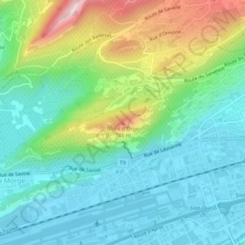
Name: Mont d'Orge topographic map, elevation, terrain.
Location: Mont d'Orge, Sion, Valais, 1950, Suisse (46.23039 7.33402 46.23049 7.33412)
Average elevation: 583 m
Minimum elevation: 477 m
Maximum elevation: 852 m
Other topographic maps
Click on a map to view its topography, its elevation and its terrain.
Château de Tourbillon
Château de Tourbillon, Chemin de la Poudrière, Petit Champsec, Sion, Valais, 1950, Suisse
Average elevation: 570 m