
La Printze topographic map
Interactive map
Click on the map to display elevation.
About this map
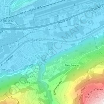
Name: La Printze topographic map, elevation, terrain.
Location: La Printze, Sion, Valais, 1950, Suisse (46.20390 7.31840 46.21028 7.32163)
Average elevation: 644 m
Minimum elevation: 475 m
Maximum elevation: 1,385 m
Other topographic maps
Click on a map to view its topography, its elevation and its terrain.
Château de Tourbillon
Château de Tourbillon, Chemin de la Poudrière, Petit Champsec, Sion, Valais, 1950, Suisse
Average elevation: 570 m