
Thank you for supporting this site ❤️
Make a donation
Make a donation
Lee County topographic map
Click on the map to display elevation.
Thank you for supporting this site ❤️
Make a donation
Make a donation
About this map
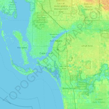
Name: Lee County topographic map, elevation, terrain.
Location: Lee County, Florida, United States (26.31613 -82.33504 26.78955 -81.56218)
Average elevation: 5 m
Minimum elevation: -2 m
Maximum elevation: 24 m
Thank you for supporting this site ❤️
Make a donation
Make a donation
Other topographic maps
Click on a map to view its topography, its elevation and its terrain.
Thank you for supporting this site ❤️
Make a donation
Make a donation
Thank you for supporting this site ❤️
Make a donation
Make a donation
Thank you for supporting this site ❤️
Make a donation
Make a donation
Miami Canal
United States > Florida > Miami-Dade County > Miami > Fronton Trailer Park
Average elevation: 7 m
Thank you for supporting this site ❤️
Make a donation
Make a donation
Legion Park
United States > Florida > Miami-Dade County > Miami > Edison Center
Average elevation: 9 m