
Thank you for supporting this site ❤️
Make a donation
Make a donation
Möderscheid topographic map
Click on the map to display elevation.
Thank you for supporting this site ❤️
Make a donation
Make a donation
About this map
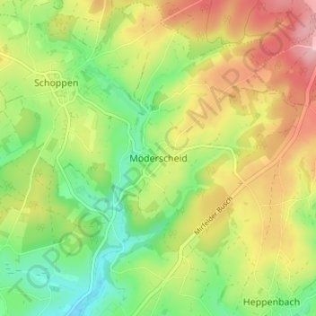
Name: Möderscheid topographic map, elevation, terrain.
Location: Möderscheid, Amblève, Verviers, Liège, Wallonie, 4771, Belgique (50.36137 6.17620 50.40137 6.21620)
Average elevation: 527 m
Minimum elevation: 449 m
Maximum elevation: 623 m
Thank you for supporting this site ❤️
Make a donation
Make a donation
Other topographic maps
Click on a map to view its topography, its elevation and its terrain.