
Querpon topographic map
Interactive map
Click on the map to display elevation.
About this map
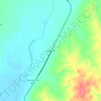
Name: Querpon topographic map, elevation, terrain.
Location: Querpon, Olmos, Lambayeque, Pérou (-5.71829 -79.90042 -5.67829 -79.86042)
Average elevation: 149 m
Minimum elevation: 128 m
Maximum elevation: 202 m
Other topographic maps
Click on a map to view its topography, its elevation and its terrain.
El Medano
Pérou > Lambayeque > Olmos > El Medano
El Medano, Olmos, Lambayeque, Pérou
Average elevation: 155 m