
Thank you for supporting this site ❤️
Make a donation
Make a donation
Anderson County topographic map
Click on the map to display elevation.
Thank you for supporting this site ❤️
Make a donation
Make a donation
About this map
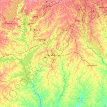
Name: Anderson County topographic map, elevation, terrain.
Location: Anderson County, South Carolina, United States (34.20875 -82.99207 34.81953 -82.31387)
Average elevation: 229 m
Minimum elevation: 136 m
Maximum elevation: 357 m
Thank you for supporting this site ❤️
Make a donation
Make a donation
Other topographic maps
Click on a map to view its topography, its elevation and its terrain.
Thank you for supporting this site ❤️
Make a donation
Make a donation
Thank you for supporting this site ❤️
Make a donation
Make a donation
Deerwood Heights
United States > South Carolina > Charleston County > North Charleston
Average elevation: 8 m