
Thank you for supporting this site ❤️
Make a donation
Make a donation
Sils im Engadin/Segl topographic map
Click on the map to display elevation.
Thank you for supporting this site ❤️
Make a donation
Make a donation
About this map
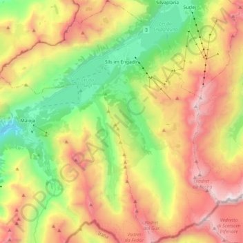
Name: Sils im Engadin/Segl topographic map, elevation, terrain.
Location: Sils im Engadin/Segl, Maloja, Grisons, Switzerland (46.34047 9.67436 46.46085 9.83232)
Average elevation: 2,455 m
Minimum elevation: 1,544 m
Maximum elevation: 3,558 m
Thank you for supporting this site ❤️
Make a donation
Make a donation
Other topographic maps
Click on a map to view its topography, its elevation and its terrain.
Diavolezza
Switzerland > Grisons > Maloja > Pontresina
The Diavolezza is a col and ski resort above the Val Bernina in Graubünden. The col has an altitude of 2,958 metres (9,705 ft) and is located between Munt Pers (northwest, 3,207 metres (10,522 ft)) and Piz Trovat (southeast, 3,146 metres (10,322 ft)).
Average elevation: 2,781 m
Thank you for supporting this site ❤️
Make a donation
Make a donation