
Thank you for supporting this site ❤️
Make a donation
Make a donation
Piz Lunghin topographic map
Click on the map to display elevation.
Thank you for supporting this site ❤️
Make a donation
Make a donation
About this map
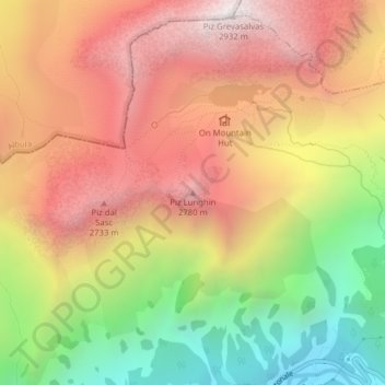
Name: Piz Lunghin topographic map, elevation, terrain.
Location: Piz Lunghin, Bregaglia, Maloja, Grisons, 7602, Switzerland (46.41046 9.67026 46.41056 9.67036)
Average elevation: 2,297 m
Minimum elevation: 1,544 m
Maximum elevation: 2,915 m
Thank you for supporting this site ❤️
Make a donation
Make a donation
Other topographic maps
Click on a map to view its topography, its elevation and its terrain.