
Make a donation
Batu Dam topographic map
Click on the map to display elevation.
Make a donation
About this map
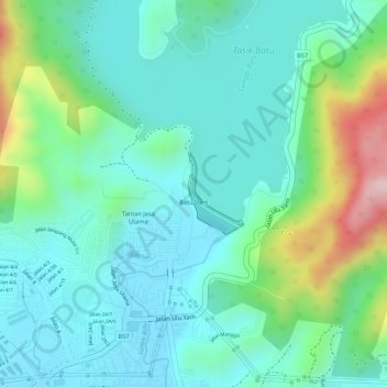
Name: Batu Dam topographic map, elevation, terrain.
Average elevation: 141 m
Minimum elevation: 65 m
Maximum elevation: 353 m
Make a donation
Other topographic maps
Click on a map to view its topography, its elevation and its terrain.
Kampung Indian Settlement Batu Caves
Malaysia > Selangor > Selayang Municipal Council > Batu Caves
Average elevation: 68 m
Make a donation
Kampung Indian Settlement Batu Caves
Malaysia > Selangor > Selayang Municipal Council > Batu Caves
Average elevation: 68 m
Kampung Sri Gombak Indah
Malaysia > Selangor > Selayang Municipal Council > Batu Caves
Average elevation: 84 m
Kampung Melayu Pekan Rawang
Malaysia > Selangor > Selayang Municipal Council > Rawang
Average elevation: 48 m
Make a donation
Kampung Selayang Indah
Malaysia > Selangor > Selayang Municipal Council > Batu Caves
Average elevation: 71 m
Kampung Gombak Utara
Malaysia > Selangor > Selayang Municipal Council > Gombak
Average elevation: 121 m
Make a donation
Kampung Selayang Baru
Malaysia > Selangor > Selayang Municipal Council > Batu Caves
Average elevation: 73 m
Kampung Laksamana
Malaysia > Selangor > Selayang Municipal Council > Batu Caves
Average elevation: 78 m
Make a donation
Kampung Indian Settlement Batu Caves
Malaysia > Selangor > Selayang Municipal Council > Batu Caves
Average elevation: 68 m
Kampung Baru Batu Caves
Malaysia > Selangor > Selayang Municipal Council > Batu Caves
Average elevation: 69 m
Make a donation
Kampung Melayu Pekan Rawang
Malaysia > Selangor > Selayang Municipal Council > Rawang
Average elevation: 48 m
Kampung Orang Asli Sungai Relang
Malaysia > Selangor > Selayang Municipal Council
Average elevation: 368 m
Kampung Melayu Pekan Rawang
Malaysia > Selangor > Selayang Municipal Council > Rawang
Average elevation: 48 m
Make a donation
Kampung Selayang Baru
Malaysia > Selangor > Selayang Municipal Council > Batu Caves
Average elevation: 73 m
Make a donation
Kampung Indian Settlement Batu Caves
Malaysia > Selangor > Selayang Municipal Council > Batu Caves
Average elevation: 68 m
Kampung Melayu Pekan Rawang
Malaysia > Selangor > Selayang Municipal Council > Rawang
Average elevation: 48 m
Make a donation
Kampung Indian Settlement Batu Caves
Malaysia > Selangor > Selayang Municipal Council > Batu Caves
Average elevation: 68 m
Kampung Sungai Serai
Malaysia > Selangor > Selayang Municipal Council > Kampung Sungai Serai
Average elevation: 54 m
Make a donation
Dark Cave (Closed)
Malaysia > Selangor > Selayang Municipal Council > Batu Caves
Average elevation: 73 m
Make a donation
Kampung Selayang Indah
Malaysia > Selangor > Selayang Municipal Council > Batu Caves > Kampung Selayang Indah
Average elevation: 76 m
Kampung Baru Batu Caves
Malaysia > Selangor > Selayang Municipal Council > Batu Caves
Average elevation: 68 m
Kampung Melayu Pekan Rawang
Malaysia > Selangor > Selayang Municipal Council > Rawang
Average elevation: 48 m
Make a donation