
Make a donation
Batu Arang topographic map
Click on the map to display elevation.
Make a donation
About this map
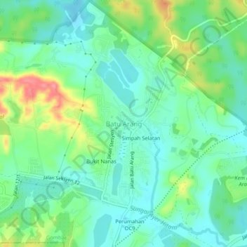
Name: Batu Arang topographic map, elevation, terrain.
Average elevation: 43 m
Minimum elevation: 16 m
Maximum elevation: 104 m
Make a donation
Other topographic maps
Click on a map to view its topography, its elevation and its terrain.
Kampung Selayang Indah
Malaysia > Selangor > Selayang Municipal Council > Batu Caves
Average elevation: 71 m
Jinjang River
Malaysia > Selangor > Selayang Municipal Council > Kampung Orang Asli Bukit Lagong
Average elevation: 223 m
Make a donation
Kampung Selayang Baru
Malaysia > Selangor > Selayang Municipal Council > Batu Caves
Average elevation: 73 m
Kampung Baru Batu Caves
Malaysia > Selangor > Selayang Municipal Council > Batu Caves
Average elevation: 69 m
Sungai Pajam
Malaysia > Selangor > Selayang Municipal Council > Rawang > Kampung Sungai Samak
Average elevation: 51 m
Make a donation
Kampung Melayu Wira Damai
Malaysia > Selangor > Selayang Municipal Council > Batu Caves
Average elevation: 91 m
Kampung Desa Kuala Garing
Malaysia > Selangor > Selayang Municipal Council > Rawang
Average elevation: 35 m
Kampung Selayang Baru
Malaysia > Selangor > Selayang Municipal Council > Batu Caves
Average elevation: 73 m
Sungai Pajam
Malaysia > Selangor > Selayang Municipal Council > Rawang > Kampung Sungai Samak
Average elevation: 86 m
Make a donation
Make a donation
Make a donation
Make a donation
Kampung Melayu Seri Gombak
Malaysia > Selangor > Selayang Municipal Council > Kampung Melayu Seri Gombak
Average elevation: 122 m