
Wani topographic map
Interactive map
Click on the map to display elevation.
About this map
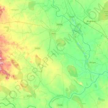
Name: Wani topographic map, elevation, terrain.
Location: Wani, Yavatmal, Maharashtra, Indien (19.76327 78.77202 20.19046 79.14900)
Average elevation: 220 m
Minimum elevation: 137 m
Maximum elevation: 414 m
Other topographic maps
Click on a map to view its topography, its elevation and its terrain.
Oros
Indien > Maharashtra > Kudal
Oros, Kudal, Sindhudurg District, Maharashtra, 416628, Indien
Average elevation: 46 m
Karjat
Indien > Maharashtra > Karjat
Karjat, Kulāba, Raigad, Maharashtra, 410201, Indien
Average elevation: 109 m
Borale
Indien > Maharashtra > Borale
Borale, Nandubar, Maharashtra, 425422, Indien
Average elevation: 118 m