Geolocate

Mayo-Kebbi Ouest topographic map

Interactive map

Click on the map to display elevation.

About this map

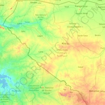
Name: Mayo-Kebbi Ouest topographic map, elevation, terrain.

Location: Mayo-Kebbi Ouest, Chad (8.46046 13.97660 10.00222 15.44100)

Average elevation: 366 m

Minimum elevation: 213 m

Maximum elevation: 829 m

Other topographic maps

Click on a map to view its topography, its elevation and its terrain.

Kanem

Chad

Kanem, Chad

Average elevation: 308 m

Omo

Chad > Hadjer-Lamis

Omo, Hadjer-Lamis, Chad

Average elevation: 306 m

Sila

Chad

Sila, Chad

Average elevation: 544 m

Kabia

Chad > Mayo-Kebbi Est

Kabia, Mayo-Kebbi Est, Chad

Average elevation: 324 m

Djagou

Chad > Lac > Djagou

Logoum 3, Djagou, Lac, Chad

Average elevation: 298 m

Batha

Chad

Batha, Chad

Average elevation: 368 m