
Thank you for supporting this site ❤️
Make a donation
Make a donation
Kruberg topographic map
Click on the map to display elevation.
Thank you for supporting this site ❤️
Make a donation
Make a donation
About this map
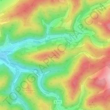
Name: Kruberg topographic map, elevation, terrain.
Location: Kruberg, Olpe, Kreis Olpe, Noordrijn-Westfalen, Duitsland (51.03700 7.90993 51.03710 7.91003)
Average elevation: 440 m
Minimum elevation: 345 m
Maximum elevation: 546 m
Thank you for supporting this site ❤️
Make a donation
Make a donation
Other topographic maps
Click on a map to view its topography, its elevation and its terrain.
Biggesee
Duitsland > Noordrijn-Westfalen > Kreis Olpe > Olpe > Sondern
Ten zuiden van Attendorn werd in 2013 het uitzichtplatform "Biggeblick" opgericht. Vanaf een camping leidt een 600 m lang pad naar het platform, waarop men vanuit een hoogte tussen de bomen een uitzicht heeft op de Biggesee.
Average elevation: 387 m