
Thank you for supporting this site ❤️
Make a donation
Make a donation
MArton Abbey topographic map
Click on the map to display elevation.
Thank you for supporting this site ❤️
Make a donation
Make a donation
About this map
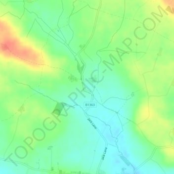
Name: MArton Abbey topographic map, elevation, terrain.
Average elevation: 49 m
Minimum elevation: 31 m
Maximum elevation: 76 m
Thank you for supporting this site ❤️
Make a donation
Make a donation
Other topographic maps
Click on a map to view its topography, its elevation and its terrain.
Thank you for supporting this site ❤️
Make a donation
Make a donation
Exelby, Leeming and Londonderry
United Kingdom > England > North Yorkshire > Hambleton
Average elevation: 35 m
Thank you for supporting this site ❤️
Make a donation
Make a donation