
Thank you for supporting this site ❤️
Make a donation
Make a donation
Whorlton topographic map
Click on the map to display elevation.
Thank you for supporting this site ❤️
Make a donation
Make a donation
About this map
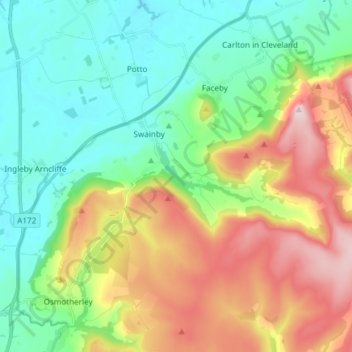
Name: Whorlton topographic map, elevation, terrain.
Location: Whorlton, Hambleton, North Yorkshire, England, United Kingdom (54.37377 -1.32480 54.42540 -1.17536)
Average elevation: 180 m
Minimum elevation: 60 m
Maximum elevation: 404 m
Thank you for supporting this site ❤️
Make a donation
Make a donation
Other topographic maps
Click on a map to view its topography, its elevation and its terrain.
The Wainstones
United Kingdom > England > North Yorkshire > Hambleton > Great Broughton
Average elevation: 231 m
Great Crakehall
United Kingdom > England > North Yorkshire > Hambleton > Great Crakehall
Average elevation: 60 m
Thank you for supporting this site ❤️
Make a donation
Make a donation
Little Crakehall
United Kingdom > England > North Yorkshire > Hambleton > Little Crakehall
Average elevation: 61 m
Seave Green
United Kingdom > England > North Yorkshire > Hambleton > Chop Gate > Seave Green
Average elevation: 264 m