
Otuzco topographic map
Interactive map
Click on the map to display elevation.
About this map
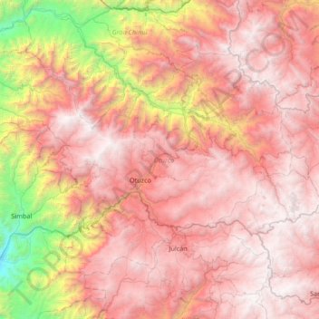
Name: Otuzco topographic map, elevation, terrain.
Location: Otuzco, La Libertad, Pérou (-8.09874 -78.91437 -7.62242 -78.24888)
Average elevation: 2,705 m
Minimum elevation: 220 m
Maximum elevation: 4,313 m
Other topographic maps
Click on a map to view its topography, its elevation and its terrain.
M
Pérou > La Libertad > Víctor Larco Herrera
M, San Andres 5ta Etapa, Vista Alegre, Víctor Larco Herrera, Trujillo, La Libertad, Pérou
Average elevation: 10 m