
Thank you for supporting this site ❤️
Make a donation
Make a donation
Pindilig topographic map
Click on the map to display elevation.
Thank you for supporting this site ❤️
Make a donation
Make a donation
About this map
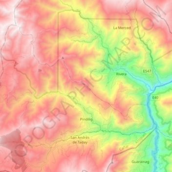
Name: Pindilig topographic map, elevation, terrain.
Location: Pindilig, Azogues, Cañar, Ecuador (-2.64825 -78.78316 -2.53058 -78.61840)
Average elevation: 3,031 m
Minimum elevation: 2,003 m
Maximum elevation: 3,807 m
Thank you for supporting this site ❤️
Make a donation
Make a donation
Other topographic maps
Click on a map to view its topography, its elevation and its terrain.
Thank you for supporting this site ❤️
Make a donation
Make a donation
Thank you for supporting this site ❤️
Make a donation
Make a donation
Thank you for supporting this site ❤️
Make a donation
Make a donation