
Thank you for supporting this site ❤️
Make a donation
Make a donation
Pajarillo topographic map
Click on the map to display elevation.
Thank you for supporting this site ❤️
Make a donation
Make a donation
About this map
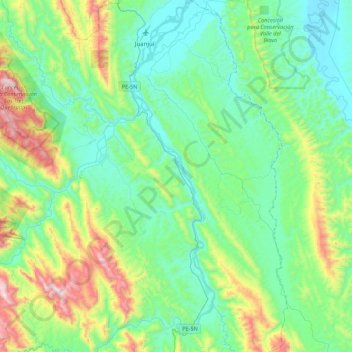
Name: Pajarillo topographic map, elevation, terrain.
Location: Pajarillo, Mariscal Cáceres, San Martín, Perú (-7.55771 -76.74488 -7.12718 -76.55135)
Average elevation: 504 m
Minimum elevation: 241 m
Maximum elevation: 1,363 m
Thank you for supporting this site ❤️
Make a donation
Make a donation
Other topographic maps
Click on a map to view its topography, its elevation and its terrain.
Thank you for supporting this site ❤️
Make a donation
Make a donation
Thank you for supporting this site ❤️
Make a donation
Make a donation