Geolocate

Motu Tane topographic map

Click on the map to display elevation.

About this map

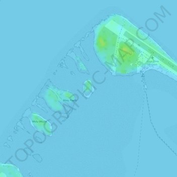
Name: Motu Tane topographic map, elevation, terrain.

Location: Motu Tane, Faanui, Bora-Bora, French Polynesia, 98730, France (-16.45051 -151.76368 -16.44762 -151.76175)

Average elevation: 1 m

Minimum elevation: 0 m

Maximum elevation: 13 m

Other topographic maps

Click on a map to view its topography, its elevation and its terrain.

Rurutu

France > French Polynesia

Average elevation: 1 m

Fakarava

France > French Polynesia > Fakarava

Average elevation: 0 m

Pāʻea

France > French Polynesia > Windward Islands

Average elevation: 252 m

Maraa

France > French Polynesia > Windward Islands > Punaʻauiʻa

Average elevation: 678 m

Windward Islands

France > French Polynesia

Average elevation: 5 m

Leeward Islands

France > French Polynesia

Average elevation: 2 m

Bora Bora

France > French Polynesia > Bora-Bora

Average elevation: 22 m

Tiputa

France > French Polynesia > Tuamotu-Gambier > Rangiroa

Average elevation: 0 m

Rangiroa

France > French Polynesia > Rangiroa

Average elevation: 0 m

Gambier Islands

France > French Polynesia

Average elevation: 2 m

Bora-Bora

France > French Polynesia > Leeward Islands

Average elevation: 1 m

Hao

France > French Polynesia > Hao

Average elevation: 0 m

Tubuai

France > French Polynesia

Hours of sunlight is about average for the Australs and is around 1970 hours per year, one of the lowest levels in Polynesia. The humidity is lower in contrast to Tahiti in the order of a few percent, mainly due to its higher latitude and its lower altitude (thus retaining fewer clouds).

Average elevation: 30 m

Windward Islands

France > French Polynesia

Average elevation: 7 m

Vaitape

France > French Polynesia > Bora-Bora > Vaitape

Average elevation: 22 m

Polynesia

France > French Polynesia

Average elevation: 1 m

Akamaru

France > French Polynesia > Gambier

Akamaru is the third largest island in the Gambier Islands of French Polynesia. It is a small, rocky island with an area of approximately 2.6 km2 (1.0 sq mi). The island is located approximately 7 km (4.3 mi) southeast of Mangareva. Its highest point rises to an elevation of 247 m (810 ft).

Average elevation: 15 m

Pukarua

France > French Polynesia > Reao

Average elevation: 0 m

Tekava

France > French Polynesia > Gambier

Average elevation: 0 m

Toau

France > French Polynesia > Fakarava

Average elevation: 0 m

Fakahina

France > French Polynesia > Fangatau

Average elevation: 0 m

Ua Pou

France > French Polynesia > Marquesas Islands > Ua Pou

It is located about 50 km (30 mi.) south of Nuku Hiva, in the northern Marquesas. The center of the island is characterized by four high basalt pillars that reach high above the surrounding mountains. The highest of these pillars, Mount Oave (Mont Oave), reaches to 1,230 m (4,040 ft) above sea level and is the…

Average elevation: 127 m

Faa'a

France > French Polynesia > Faaa

Average elevation: 82 m