
Thank you for supporting this site ❤️
Make a donation
Make a donation
Pāʻea topographic map
Click on the map to display elevation.
Thank you for supporting this site ❤️
Make a donation
Make a donation
About this map
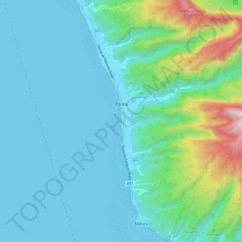
Name: Pāʻea topographic map, elevation, terrain.
Location: Pāʻea, Windward Islands, French Polynesia, 98711, France (-17.74743 -149.59634 -17.64485 -149.50062)
Average elevation: 252 m
Minimum elevation: 0 m
Maximum elevation: 1,461 m
Thank you for supporting this site ❤️
Make a donation
Make a donation
Other topographic maps
Click on a map to view its topography, its elevation and its terrain.