
Make a donation
Salar de Atacama topographic map
Click on the map to display elevation.
Make a donation
Salar de Atacama
The salt flat encompasses 3,000 km2 (1,200 sq mi), is about 100 km (62 mi) long and 80 km (50 mi) wide, which makes it the third largest in the world, after Salar de Uyuni in Bolivia (10,582 km2 (4,086 sq mi)). and Salinas Grandes in Argentina (6,000 km2 (2,300 sq mi)). Its average elevation is about 2,300 m above sea level. The topography of the core portion of the salar exhibits a high level of roughness, the result of evaporation and ephemeral surface water, unlike the most other salt flats, as for example the Salar de Uyuni, which is periodically covered with shallow water.
Make a donation
About this map
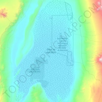
Name: Salar de Atacama topographic map, elevation, terrain.
Location: Salar de Atacama, Antofagasta Region, Chile (-23.78629 -68.57340 -22.98237 -68.06436)
Average elevation: 2,650 m
Minimum elevation: 2,298 m
Maximum elevation: 5,294 m
Make a donation
Other topographic maps
Click on a map to view its topography, its elevation and its terrain.
Atacama Desert
Chile > Antofagasta Region > Provincia de Antofagasta > Antofagasta
The Coastal Cliff of northern Chile west of the Chilean Coast Range is the main topographical feature of the coast. The geomorphology of the Atacama Desert has been characterized as a low-relief bench "similar to a giant uplifted terrace" by Armijo and co-workers. The intermediate depression (or Central…
Average elevation: 1,961 m
Camar
Chile > Antofagasta Region > Provincia de El Loa > San Pedro de Atacama
Average elevation: 2,722 m
Socaire
Chile > Antofagasta Region > Provincia de El Loa > San Pedro de Atacama
Average elevation: 3,291 m
Make a donation
Laguna Lejía
Chile > Antofagasta Region > Provincia de El Loa > San Pedro de Atacama
Lejía Lake is a circular, shallow lake at an elevation of 4,325 metres (14,190 ft) with a surface area of 1.9 square kilometres (0.73 sq mi) or 2 square kilometres (0.77 sq mi). It is a polymictic lake which freezes over occasionally and whose waters are turned over quickly, mainly through evaporation. Winds…
Average elevation: 4,341 m
A018
Chile > Antofagasta Region > Provincia de El Loa > San Pedro de Atacama > Atacama Large Millimeter/submillimeter Array
Average elevation: 5,021 m
Volcán Ojos del Toro
Chile > Antofagasta Region > Provincia de El Loa > San Pedro de Atacama
Average elevation: 5,503 m
Volcán Llullaillaco
Chile > Antofagasta Region > Provincia de Antofagasta > Antofagasta
Llullaillaco (Spanish: [ʎuʎajˈʎako], Latin American Spanish: [ɟʝuʝajˈʝako]) is a dormant stratovolcano on the border between Argentina (Salta Province) and Chile (Antofagasta Region). It is part of the Llullaillaco National Park and lies in the Puna de Atacama, a region of tall volcanic peaks on a…
Average elevation: 6,187 m
Make a donation
Norte Grande
Chile > Antofagasta Region > Provincia de Antofagasta > Sierra Gorda
The desert region is an elevated arid plateau descending gradually from the Andes towards the coast, where it breaks down abruptly from elevations of 800 to 1500 ft. From the sea this plateau escarpment has the appearance of a range of flat topped hills closely following the coast line. This topography…
Average elevation: 2,112 m
Atacama Desert
Chile > Antofagasta Region > Provincia de Antofagasta > Antofagasta
The Coastal Cliff of northern Chile west of the Chilean Coast Range is the main topographical feature of the coast. The geomorphology of the Atacama Desert has been characterized as a low-relief bench "similar to a giant uplifted terrace" by Armijo and co-workers. The intermediate depression (or Central…
Average elevation: 1,961 m
Guatín
Chile > Antofagasta Region > Provincia de El Loa > San Pedro de Atacama
Average elevation: 3,275 m
Make a donation
Atacama Desert
Chile > Antofagasta Region > Provincia de Antofagasta > Antofagasta
The Coastal Cliff of northern Chile west of the Chilean Coast Range is the main topographical feature of the coast. The geomorphology of the Atacama Desert has been characterized as a low-relief bench "similar to a giant uplifted terrace" by Armijo and co-workers. The intermediate depression (or Central…
Average elevation: 1,961 m
Make a donation
Lascar
Chile > Antofagasta Region > Provincia de El Loa > San Pedro de Atacama
Large lava flows are noticeable on the flanks of the volcano, with a total of eight lava flows recognized. They extend from the summit craters, although none of them appear to be associated with the currently active crater. Flows from the first stage of Lascar's activity are exposed at its western foot, while…
Average elevation: 5,269 m
Norte Grande
Chile > Antofagasta Region > Provincia de Antofagasta > Sierra Gorda
The desert region is an elevated arid plateau descending gradually from the Andes towards the coast, where it breaks down abruptly from elevations of 800 to 1500 ft. From the sea this plateau escarpment has the appearance of a range of flat topped hills closely following the coast line. This topography…
Average elevation: 2,112 m
Make a donation
Valle de la Luna
Chile > Antofagasta Region > Provincia de El Loa > San Pedro de Atacama
Average elevation: 2,531 m
Coyo
Chile > Antofagasta Region > Provincia de El Loa > San Pedro de Atacama
Average elevation: 2,397 m
Atacama Large Millimeter/submillimeter Array
Chile > Antofagasta Region > Provincia de El Loa > San Pedro de Atacama > Atacama Large Millimeter/submillimeter Array
The Atacama Large Millimeter/submillimeter Array (ALMA) is an astronomical interferometer of 66 radio telescopes in the Atacama Desert of northern Chile, which observe electromagnetic radiation at millimeter and submillimeter wavelengths. The array has been constructed on the 5,000 m (16,000 ft) elevation…
Average elevation: 5,010 m
Quillagua
Chile > Antofagasta Region > Provincia de Tocopilla > María Elena > Quillagua
Average elevation: 871 m
Make a donation
Salar de Navidad
Chile > Antofagasta Region > Provincia de Antofagasta > Antofagasta
Average elevation: 697 m
Chaxas
Chile > Antofagasta Region > Provincia de El Loa > San Pedro de Atacama
Average elevation: 3,939 m
Cerro Colorado
Chile > Antofagasta Region > Provincia de Antofagasta > Taltal
Average elevation: 814 m
Make a donation
View of astronomy array system to west
Chile > Antofagasta Region > Provincia de El Loa > San Pedro de Atacama
Average elevation: 4,649 m