
Make a donation
Volcán Llullaillaco topographic map
Click on the map to display elevation.
Make a donation
Volcán Llullaillaco
Llullaillaco (Spanish: [ʎuʎajˈʎako], Latin American Spanish: [ɟʝuʝajˈʝako]) is a dormant stratovolcano on the border between Argentina (Salta Province) and Chile (Antofagasta Region). It is part of the Llullaillaco National Park and lies in the Puna de Atacama, a region of tall volcanic peaks on a high plateau close to the Atacama Desert, one of the driest places in the world. Its maximum elevation is most commonly given as 6,723 metres (22,057 ft), making it the second-highest active volcano in the world. Despite its height, it is not clear whether the volcano has any glaciers or merely patches of perennial snow and ice. Between 3,700 m and 5,000 m elevation there is a sparse plant cover, while at lower altitudes the climate is too dry for plants to grow. A species of mouse on Llullaillaco is the vertebrate species living at the highest-known altitude.
Make a donation
About this map
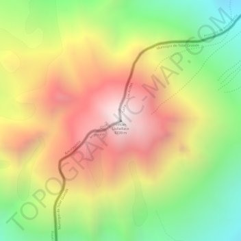
Name: Volcán Llullaillaco topographic map, elevation, terrain.
Average elevation: 6,187 m
Minimum elevation: 5,581 m
Maximum elevation: 6,733 m
Make a donation
Other topographic maps
Click on a map to view its topography, its elevation and its terrain.
Parque Nacional Morro Moreno
Chile > Antofagasta Region > Provincia de Antofagasta > Antofagasta
Average elevation: 204 m
Salar de Navidad
Chile > Antofagasta Region > Provincia de Antofagasta > Antofagasta
Average elevation: 697 m