
Cumberland County topographic map
Interactive map
Click on the map to display elevation.
About this map
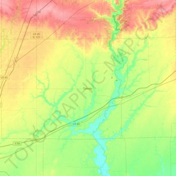
Name: Cumberland County topographic map, elevation, terrain.
Location: Cumberland County, Illinois, USA (39.17010 -88.47154 39.37896 -88.00857)
Average elevation: 189 m
Minimum elevation: 150 m
Maximum elevation: 241 m
Other topographic maps
Click on a map to view its topography, its elevation and its terrain.
West Union
USA > Illinois > West Union
West Union, Clark County, Illinois, 62477, USA
Average elevation: 148 m
Island Grove
USA > Illinois > Island Grove
Island Grove, Jasper County, Illinois, USA
Average elevation: 181 m
Garfield Ridge
Garfield Ridge, Chicago, Cook County, Illinois, USA
Average elevation: 184 m
Montague Island
Montague Island, Rockford, Winnebago County, Illinois, 61104, USA
Average elevation: 254 m
Gilligans Island
Gilligans Island, Nauvoo, Hancock County, Illinois, USA
Average elevation: 183 m