
Thank you for supporting this site ❤️
Make a donation
Make a donation
Cresson topographic map
Click on the map to display elevation.
Thank you for supporting this site ❤️
Make a donation
Make a donation
About this map
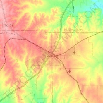
Name: Cresson topographic map, elevation, terrain.
Location: Cresson, Hood County, Texas, United States (32.48102 -97.66926 32.58877 -97.56608)
Average elevation: 303 m
Minimum elevation: 235 m
Maximum elevation: 353 m
Thank you for supporting this site ❤️
Make a donation
Make a donation
Other topographic maps
Click on a map to view its topography, its elevation and its terrain.