
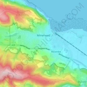
Minehead topographic map
Interactive map
Click on the map to display elevation.
About this map
Name: Minehead topographic map, elevation, terrain.
Average elevation: 86 m
Minimum elevation: 0 m
Maximum elevation: 295 m
Other topographic maps
Click on a map to view its topography, its elevation and its terrain.
Luxborough
United Kingdom > England > Somerset > Somerset West and Taunton
Luxborough, Somerset West and Taunton, Somerset, England, United Kingdom
Average elevation: 292 m
Allerford
United Kingdom > England > Somerset > Somerset West and Taunton > Allerford
Allerford, Somerset West and Taunton, Somerset, England, TA24 8HN, United Kingdom
Average elevation: 112 m
Porlock
United Kingdom > England > Somerset > Somerset West and Taunton > Porlock
Porlock, Somerset West and Taunton, Somerset, England, United Kingdom
Average elevation: 207 m
Bossington
United Kingdom > England > Somerset > Somerset West and Taunton > Bossington
Bossington, Somerset West and Taunton, Somerset, England, TA24 8HQ, United Kingdom
Average elevation: 69 m
Horner Water
United Kingdom > England > Somerset > Somerset West and Taunton > Luccombe
Horner Water, Luccombe, Somerset West and Taunton, Somerset, England, TA24 8HY, United Kingdom
Average elevation: 248 m
Halse Combe
United Kingdom > England > Somerset > Somerset West and Taunton > Allerford > Horner
Halse Combe, Horner, Luccombe, Allerford, Somerset West and Taunton, Somerset, England, TA24 8HX, United Kingdom
Average elevation: 134 m
Watchet
United Kingdom > England > Somerset > Somerset West and Taunton
Watchet, Somerset West and Taunton, Somerset, England, United Kingdom
Average elevation: 20 m
Taunton
United Kingdom > England > Somerset > Somerset West and Taunton
Taunton, Somerset West and Taunton, Somerset, England, TA1 1JD, United Kingdom
Average elevation: 39 m